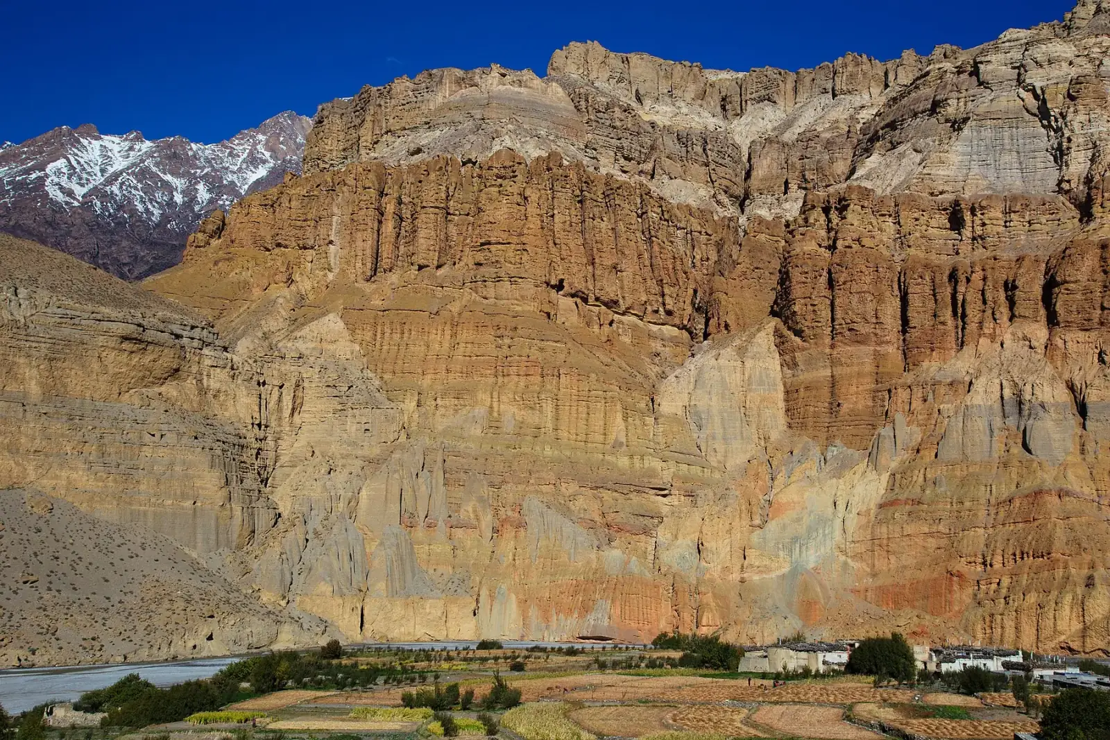
Photo: Jean-Marie Hullot from France · CC BY 2.0 · Wikimedia Commons
Upper Mustang
The forbidden kingdom — Tibetan culture beyond the Himalayas
The Upper Mustang trek takes you into one of the most isolated and culturally preserved regions in the world. For centuries, the Kingdom of Lo was a forbidden territory, closed to outsiders until 1992. Over 12 days, you will trek through a surreal landscape of wind-carved cliffs, ancient cave dwellings, and red-walled monasteries to reach Lo Manthang (3,840m), the walled capital of this former Tibetan kingdom. This is not a mountain-scenery trek — it is a journey into a living medieval culture where Tibetan Buddhism thrives unchanged by modernity.
Book Upper Mustang
No obligation. Or call +977-9849998031
Route map
Waypoints
- Day 1 — Jomsom 2,800 m
- Day 1 — Kagbeni 2,804 m
- Day 2 — Chele 3,050 m
- Day 3 — Samar 3,600 m
- Day 3 — Syangboche 3,475 m
- Day 4 — Nyi La 4,010 m
- Day 4 — Ghami 3,520 m
- Day 5 — Charang 3,570 m
- Day 6 — Lo Manthang 3,840 m
- Day 7 — Lo Manthang 3,840 m
- Day 8 — Dhakmar 3,820 m
- Day 9 — Ghiling 3,570 m
- Day 10 — Chhuksang 2,980 m
- Day 11 — Jomsom 2,800 m
Map key
- Surveyed trail
- Follows the road — no separate trail mapped
Elevation profile
| Day | Place | Altitude | Gain from previous night |
|---|---|---|---|
| 1 | Kagbeni | 2,804 m | first night |
| 2 | Chele | 3,050 m | +246 m |
| 3 | Syangboche | 3,475 m | +425 m |
| 4 | Ghami | 3,520 m | +45 m |
| 5 | Charang | 3,570 m | +50 m |
| 6 | Lo Manthang | 3,840 m | +270 m |
| 7 | Lo Manthang | 3,840 m | 0 m |
| 8 | Dhakmar | 3,820 m | -20 m |
| 9 | Ghiling | 3,570 m | -250 m |
| 10 | Chhuksang | 2,980 m | -590 m |
| 11 | Jomsom | 2,800 m | -180 m |
High points on this route that are not sleeping altitudes:
- Nyi La (day 4): 4,010 m
Terrain elevation interpolated between waypoints by SRTM30m — not the route's sourced altitudes. May read above or below maxAltitude/maxSleepAltitude (both cited, manual figures); render or label accordingly, do not treat as the same number.
Acclimatisation
No night on this itinerary gains more than 500 m of sleeping altitude above 3,000 m. 0 of its 1 rest days follow the largest gains. The highest night is 3,840 m.
| Day | Sleeping at | Altitude | Gain from previous night | Rest day |
|---|---|---|---|---|
| 1 | Kagbeni | 2,804 m | first night | |
| 2 | Chele | 3,050 m | +246 m | |
| 3 | Syangboche | 3,475 m | +425 m | |
| 4 | Ghami | 3,520 m | +45 m | |
| 5 | Charang | 3,570 m | +50 m | |
| 6 | Lo Manthang | 3,840 m | +270 m | |
| 7 | Lo Manthang | 3,840 m | 0 m | Rest day |
| 8 | Dhakmar | 3,820 m | -20 m | |
| 9 | Ghiling | 3,570 m | -250 m | |
| 10 | Chhuksang | 2,980 m | -590 m | |
| 11 | Jomsom | 2,800 m | -180 m |
Cited to the Wilderness Medical Society Clinical Practice Guidelines (2024): above 3,000 m, do not increase sleeping elevation by more than 500 m per day, and take a rest day every 3–4 days. WMS itself notes that terrain often makes strict adherence impossible.
This is itinerary information, not medical advice, and not clearance to trek. Acclimatisation varies between individuals.
Your trip, day by day — all 12 days, travel included
Every day of the 12-day trip in the order it happens, including the flights, drives and rest days that have no walking stage. These are trip day numbers. The next section numbers walking days instead, starting again at 1, so a day number here and a walking day number there are not the same day.
- Day 1 of 12
Kathmandu to Pokhara — Flight to Jomsom (2,800m)
Fly from Kathmandu to Pokhara (25 min), then connect to Jomsom through the Kali Gandaki gorge — one of the world's most spectacular short flights. Settle into Jomsom and acclimatize. Briefing with your guide.
- Day 2 of 12
Jomsom to Kagbeni (2,804m)
Short trek along the Kali Gandaki riverbed to Kagbeni, the gateway to Upper Mustang. This medieval village with its narrow alleys and ancient Buddhist temple marks the boundary of the restricted area. Permit checkpoint. Walking time: 3-4 hours.
- Day 3 of 12
Kagbeni to Chele (3,050m)
Enter the restricted zone. The landscape changes dramatically — green valleys give way to arid, wind-sculpted canyons. Trek along the Kali Gandaki and climb to Chele, a village perched on red cliffs. Walking time: 5-6 hours.
- Day 4 of 12
Chele to Syangboche (3,475m)
Cross two high passes — Chele La and Samar La. The terrain is otherworldly: eroded red and ochre cliffs, wind-carved pillars, and vast open plains. Pass through the village of Samar. Walking time: 6-7 hours.
- Day 5 of 12
Syangboche to Ghami (3,520m)
Trek across the high plateau. Pass the longest mani wall in Nepal (over 500m of prayer-carved stones) near Ghami. The wind is constant at this altitude, and the landscape feels like the Tibetan Plateau. Walking time: 5-6 hours.
- Day 6 of 12
Ghami to Charang (3,570m)
Cross the Nyi La pass (4,010m) with views of the Damodar Himal. Descend to Charang, the second-largest settlement in Upper Mustang. Visit the Charang Dzong (fort) and the ancient monastery with remarkable murals. Walking time: 5-6 hours.
- Day 7 of 12
Charang to Lo Manthang (3,840m)
The culmination of the trek. Cross the Lo La pass and see the walled city of Lo Manthang appear across the plateau. Enter through the ancient gates into a medieval Tibetan town of 150 houses, four monasteries, and the Royal Palace of the King of Mustang. Walking time: 4-5 hours.
- Day 8 of 12
Explore Lo Manthang
Full day exploring the walled city. Visit the Champa Lhakhang (God House), Thubchen Gompa with its extraordinary 15th-century murals, and the Choede Monastery. Meet local artisans and, schedule permitting, the royal family. Optional excursion to the Chhoser caves.
- Day 9 of 12
Lo Manthang to Dhakmar (3,820m)
Begin the return journey via a different route where possible. Descend across the high plateau to Dhakmar, known for the red cliffs rising above the village — the same eroded, wind-carved landscape seen from a new angle.
- Day 10 of 12
Dhakmar to Ghiling (3,570m)
Continue south through the canyon country to Ghiling. The return journey often reveals details missed on the way up — cave dwellings, hidden chortens, and eagle nests in the cliff faces.
- Day 11 of 12
Ghiling to Chhuksang (2,980m)
Descend back through the dramatic landscape toward Chhuksang, on the eastern side of the Kali Gandaki. The greenery of the valley below is a stark contrast to the arid upper region. Farewell dinner with the team.
- Day 12 of 12
Chhuksang to Jomsom — Fly to Pokhara/Kathmandu
Short walk down to Jomsom and morning flight to Pokhara, connecting to Kathmandu. Alternatively, spend an extra night in Pokhara by the lake. Airport transfer for departure.
Walking days on the mapped route — 11 days of sourced altitudes
Numbered by walking day: walking day 1 is the first day with a mapped stage. Every altitude below is a waypoint from this route's own sources, listed at the foot of the page.
- Jomsom 2,800 m
day stop
Flight from Pokhara; Mustang district headquarters in the Kali Gandaki gorge. Same node/altitude as the annapurna-circuit route’s Jomsom waypoint (identical real place). Not overnighted — the loop continues on foot/jeep to Kagbeni the same day.
- Kagbeni 2,804 m
overnight
Last village before the restricted zone; permit checkpoint. Published altitude from Wikipedia (2,804m); wildernessexcursion.com gives 2,858m — normal source spread. OSM’s node carries the name "Kāgbeni" with a macron diacritic that the resolver’s ASCII-only normaliser does not strip, so the automatic exact-match path misses it; confirmed manually (diacritic-stripped normalisation matches exactly, and it is the only node of that name in the cache) before use.
- Chele 3,050 m
overnight
Entry to the walled sections of the restricted area. OSM exact match, place=village.
- Samar 3,600 m
day stop
Passed through crossing from Chele to Syangboche, alongside the two passes the prose calls Chele La and Samar La (day4 title/description) — neither of which has a name match in the cached OSM data for this region (see task-4b-report.md); not modelled as separate waypoints. OSM node 5669666194 (place=village, name="Samar", old_name="Samargaon") confirms the coordinate but carries no ele tag. The committed geo/upper-mustang.json line passes 16m from this node (profile index 1985 of densify(coords,0.5), which does not insert extra points on this line — see elevation.ts); its cached OpenTopoData sample (.cache/routes/elev-upper-mustang.json[1985]) reads 3600m, 20m below the 3,620m the prose's day-10 title separately quotes for this same village on the return leg. Note: the spine's own return leg (Lo Manthang -> Dhakmar -> Ghiling -> Chhuksang -> Jomsom) does not pass through Samar at all — a second, real return route via Ghami/Samar/Kagbeni that the prose's days 9-11 describe instead. That divergence is unresolved here, the same class of issue as Tadapani/Ghandruk on annapurna-circuit; only this single outbound occurrence is modelled.
- Syangboche 3,475 m
overnight
Also spelled Syanbochen/Syangmochen in itinerary sources; OSM maps this node as "Sangboche" (place=village) — no candidate normalises exactly to any of the trekking-guide spellings, so this is a manual fuzzy match confirmed by its position on the Chele–Ghami trail and consistent day-stage distance. Crossed en route: Taklam La (~3,624m), not modelled as a separate waypoint.
- Nyi La 4,010 m
day stop
Highest point of the standard loop, crossed the same day as the lower Yamda La (~3,850m, not modelled separately). OSM exact match (mountain_pass=yes) with ele=4010 — an exact match to the published figure.
- Ghami 3,520 m
overnight
OSM exact match, place=village.
- Charang 3,570 m
overnight
Also spelled Tsarang. Altitude from Wikipedia (Charang, Nepal). OSM node is named "Charang".
- Lo Manthang 3,840 m
overnight
Walled former capital of the Kingdom of Lo. 3,840m is the figure given by Wikipedia (via Lomanthang Rural Municipality) and the most frequently cited across sources; some operator itineraries list overnight altitude as low as 3,700m for the same town — within this catalog’s normal source-disagreement range. OSM node has no ele tag.
- Lo Manthang 3,840 m
overnight
Second night — the exploration/acclimatization day, visiting Chode, Jampa and Thupchen monasteries.
- Dhakmar 3,820 m
overnight
Also spelled Drakmar. Known for its red cliffs. OSM exact match (as "Dhakmar").
- Ghiling 3,570 m
overnight
OSM maps this node as "Ghilin" — no exact match to any trekking-guide spelling; manual fuzzy match confirmed by position on the return trail between Dhakmar and Chhuksang. Altitude sources disagree fairly widely for this village (3,570m most commonly cited vs. 3,805–3,820m in a couple of itineraries, which look like a copy from the neighbouring Dhakmar figure); used the more frequently corroborated 3,570m.
- Chhuksang 2,980 m
overnight
OSM maps this node as "Chhusang" — manual fuzzy match, confirmed by position on the return trail and consistent with goingthewholehogg.com’s 2,980m figure for the same village on the eastern return route.
- Jomsom 2,800 m
overnight
Return to Jomsom for the flight out to Pokhara the following day (not modelled as a separate waypoint).
The remaining 1 day of this 12-day trip cover travel to and from the trailhead, and buffer time for delays en route — the specifics vary by route.
Permits
| Permit | Fee | Verified |
|---|---|---|
| Upper Mustang Restricted Area Permit | USD 50 | Verified 2026-09-07 |
| Annapurna Conservation Area Permit | NPR 3,000 | Verified 2026-09-07 |
Cost breakdown
- Permits (NPR)
- NPR 3,000
- Permits (USD)
- USD 50
Permit fees above are the only figures on this page we have re-verified against the issuing authority; the route's itinerary and altitudes are built from the sources listed further down this page, not independently re-verified with one. Other trip costs — teahouse accommodation, a guide, a porter, and flights where the route requires one — vary by season, operator and party size and are not itemised here.
When to go
Month-by-month fit for Upper Mustang, based on this route's own best-months window.
- Jan avoid
- Feb shoulder
- Mar best
- Apr best
- May best
- Jun best
- Jul best
- Aug best
- Sep best
- Oct best
- Nov best
- Dec shoulder
Upper Mustang — Frequently Asked Questions
Why is Upper Mustang so expensive?
How hard is the Upper Mustang trek?
When is the best time to trek Upper Mustang?
Is the King of Mustang still there?
Can I combine Upper Mustang with other treks?
Sources
- https://www.exploreinnepal.com/upper-mustang-trek-12-days/
- https://wildernessexcursion.com/trip/upper-mustang-trek
- https://nepalgram.com/trip/upper-mustang-trek-12-days/
- https://en.wikipedia.org/wiki/Lo_Manthang
- https://en.wikipedia.org/wiki/Charang,_Nepal
- https://en.wikipedia.org/wiki/Kagbeni,_Mustang
- https://en.wikipedia.org/wiki/Jomsom
- https://www.mustangtreknepal.com/villages-of-upper-mustang-valley-nepal
- https://www.goingthewholehogg.com/upper-mustang-trek-guide/
- https://www.immigration.gov.np/trekking-route-and-permit-fee
Ready to book Upper Mustang?
12 days in the Mustang & the far west region, highest night at 3,840 m, from USD 1,500.