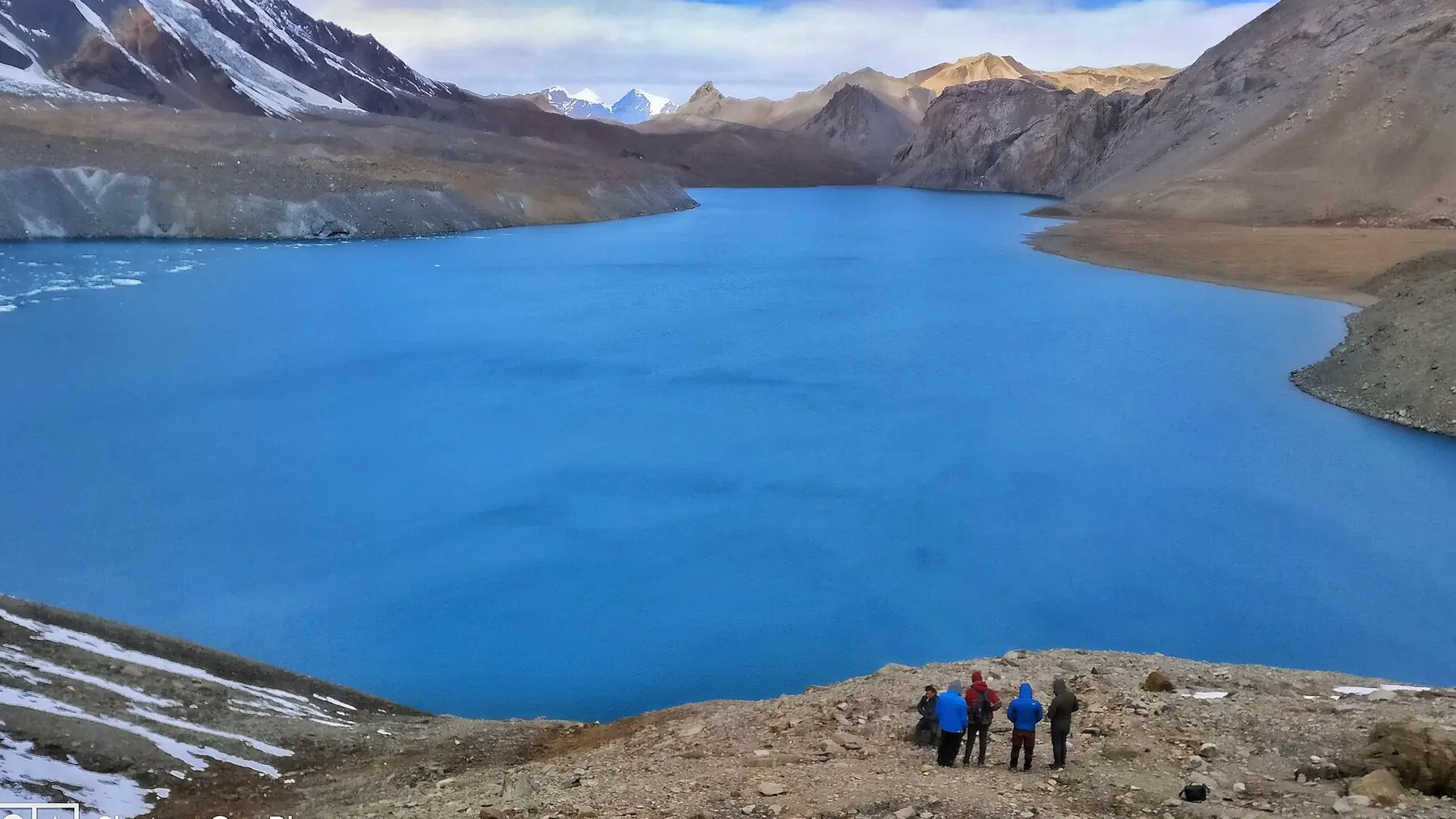
Photo: Amogh Risal · CC BY-SA 4.0 · Wikimedia Commons · resized; shared under the same licence
Annapurna Circuit with Tilicho Lake
The full Annapurna Circuit, extended to the world's highest lake
This is the Annapurna Circuit's classic counter-clockwise route around the Annapurna massif, extended over 20 days with a side trip from Khangsar to Tilicho Lake (4,919m), one of the highest lakes on Earth. It still crosses Thorong La (5,416m), the circuit's high point, and shares the same descent through Muktinath, Marpha and the Kali Gandaki gorge as the shorter 18-day Annapurna Circuit — the difference is the extra days spent reaching Tilicho before rejoining the main trail at Yak Kharka.
Book Annapurna Circuit with Tilicho Lake
No obligation. Or call +977-9849998031
Route map
Waypoints
- Day 1 — Dharapani 1,860 m
- Day 2 — Chame 2,670 m
- Day 3 — Upper Pisang 3,300 m
- Day 4 — Ngawal 3,660 m
- Day 5 — Manang 3,540 m
- Day 6 — Manang 3,540 m
- Day 7 — Khangsar 3,756 m
- Day 8 — Tilicho Base Camp 4,150 m
- Day 9 — Tilicho Lake 4,919 m
- Day 9 — Tilicho Base Camp 4,150 m
- Day 10 — Yak Kharka 4,018 m
- Day 11 — Thorong Phedi 4,540 m
- Day 12 — Thorong La 5,416 m
- Day 12 — Muktinath 3,762 m
- Day 13 — Jomsom 2,800 m
- Day 14 — Marpha 2,670 m
- Day 15 — Tatopani 1,190 m
- Day 16 — Ghorepani 2,850 m
- Day 17 — Poon Hill 3,210 m
- Day 17 — Tikhedhunga 1,480 m
- Day 18 — Birethanti 1,025 m
Map key
- Surveyed trail
- Follows the road — no separate trail mapped
Elevation profile
| Day | Place | Altitude | Gain from previous night |
|---|---|---|---|
| 1 | Dharapani | 1,860 m | first night |
| 2 | Chame | 2,670 m | +810 m |
| 3 | Upper Pisang | 3,300 m | +630 m |
| 4 | Ngawal | 3,660 m | +360 m |
| 5 | Manang | 3,540 m | -120 m |
| 6 | Manang | 3,540 m | 0 m |
| 7 | Khangsar | 3,756 m | +216 m |
| 8 | Tilicho Base Camp | 4,150 m | +394 m |
| 9 | Tilicho Base Camp | 4,150 m | 0 m |
| 10 | Yak Kharka | 4,018 m | -132 m |
| 11 | Thorong Phedi | 4,540 m | +522 m |
| 12 | Muktinath | 3,762 m | -778 m |
| 13 | Jomsom | 2,800 m | -962 m |
| 14 | Marpha | 2,670 m | -130 m |
| 15 | Tatopani | 1,190 m | -1,480 m |
| 16 | Ghorepani | 2,850 m | +1,660 m |
| 17 | Tikhedhunga | 1,480 m | -1,370 m |
| 18 | Birethanti | 1,025 m | -455 m |
High points on this route that are not sleeping altitudes:
- Thorong La (day 12): 5,416 m
Terrain elevation interpolated between waypoints by SRTM30m — not the route's sourced altitudes. May read above or below maxAltitude/maxSleepAltitude (both cited, manual figures); render or label accordingly, do not treat as the same number.
Acclimatisation
2 nights on this itinerary gain more than 500 m of sleeping altitude: Upper Pisang (+630 m), Thorong Phedi (+522 m). 0 of its 2 rest days follow the largest gains. The highest night is 4,540 m.
| Day | Sleeping at | Altitude | Gain from previous night | Rest day |
|---|---|---|---|---|
| 1 | Dharapani | 1,860 m | first night | |
| 2 | Chame | 2,670 m | +810 m | |
| 3 | Upper Pisang | 3,300 m | +630 m (above the 500 m guideline) | |
| 4 | Ngawal | 3,660 m | +360 m | |
| 5 | Manang | 3,540 m | -120 m | |
| 6 | Manang | 3,540 m | 0 m | Rest day |
| 7 | Khangsar | 3,756 m | +216 m | |
| 8 | Tilicho Base Camp | 4,150 m | +394 m | |
| 9 | Tilicho Base Camp | 4,150 m | 0 m | Rest day |
| 10 | Yak Kharka | 4,018 m | -132 m | |
| 11 | Thorong Phedi | 4,540 m | +522 m (above the 500 m guideline) | |
| 12 | Muktinath | 3,762 m | -778 m | |
| 13 | Jomsom | 2,800 m | -962 m | |
| 14 | Marpha | 2,670 m | -130 m | |
| 15 | Tatopani | 1,190 m | -1,480 m | |
| 16 | Ghorepani | 2,850 m | +1,660 m | |
| 17 | Tikhedhunga | 1,480 m | -1,370 m | |
| 18 | Birethanti | 1,025 m | -455 m |
Cited to the Wilderness Medical Society Clinical Practice Guidelines (2024): above 3,000 m, do not increase sleeping elevation by more than 500 m per day, and take a rest day every 3–4 days. WMS itself notes that terrain often makes strict adherence impossible.
This is itinerary information, not medical advice, and not clearance to trek. Acclimatisation varies between individuals.
Your trip, day by day — all 20 days, travel included
Every day of the 20-day trip in the order it happens, including the flights, drives and rest days that have no walking stage. These are trip day numbers. The next section numbers walking days instead, starting again at 1, so a day number here and a walking day number there are not the same day.
- Day 1 of 20
Kathmandu — Arrival & Orientation
Arrive in Kathmandu, meet the guide team, and review permits and the itinerary ahead of an early departure the next morning.
- Day 2 of 20
Drive to Dharapani (1,860m)
A long jeep drive from Besisahar follows the Marsyangdi valley through Bhulbhule, Jagat, Chamje and Tal to Dharapani (1,860m), a permit checkpoint and the start of the trekking days ahead.
- Day 3 of 20
Dharapani to Chame (2,670m)
The valley narrows and the forest thickens on the way to Chame (2,670m), the district headquarters of Manang.
- Day 4 of 20
Chame to Upper Pisang (3,300m)
Continue up the Marsyangdi valley via Bhratang and Dhukur Pokhari to Upper Pisang (3,300m), where the architecture turns visibly Tibetan.
- Day 5 of 20
Upper Pisang to Ngawal (3,660m)
The high route via Ghyaru climbs deliberately before dropping into the Manang valley, reaching Ngawal (3,660m) with wide views back down the valley.
- Day 6 of 20
Ngawal to Manang (3,540m)
A net descent from Ngawal brings the trail into Manang (3,540m), the last major trading village before the climb toward Thorong La.
- Day 7 of 20
Acclimatization Day in Manang (3,540m)
A rest day for altitude adjustment before the trail turns toward Khangsar and the Tilicho side trip.
- Day 8 of 20
Manang to Khangsar (3,756m)
Leave the main circuit trail at Khangsar (3,756m), the turn-off point for Tilicho Lake.
- Day 9 of 20
Khangsar to Tilicho Base Camp (4,150m)
The trail crosses an exposed, landslide-prone traverse below the pass, via Shree Kharka, to reach Tilicho Base Camp (4,150m).
- Day 10 of 20
Day Hike to Tilicho Lake (4,919m) — Return to Tilicho Base Camp (4,150m)
A day trip up to Tilicho Lake (4,919m), one of the highest lakes in the world, held in a bowl of scree and moraine below the surrounding peaks. The trail returns the same way to Tilicho Base Camp (4,150m) for the night.
- Day 11 of 20
Tilicho Base Camp to Yak Kharka (4,018m)
Rejoin the main circuit trail at Yak Kharka (4,018m), where yak herders graze their animals on the thinning, drier pasture above Manang.
- Day 12 of 20
Yak Kharka to Thorong Phedi (4,540m)
A shorter day to Thorong Phedi (4,540m), the staging point below Thorong La, with an early dinner ahead of the pass crossing.
- Day 13 of 20
Cross Thorong La (5,416m) — Descend to Muktinath (3,762m)
The highest point of the route, crossed before dawn rather than slept at. The descent on the far side drops more than 1,600m in a single day to Muktinath (3,762m), where trekkers overnight at Ranipauwa, the lodge village immediately below the sacred temple.
- Day 14 of 20
Muktinath to Jomsom (2,800m)
Descend into the arid, Tibetan-influenced Kali Gandaki valley to Jomsom (2,800m), the Mustang district headquarters.
- Day 15 of 20
Jomsom to Marpha (2,670m)
A short day down the Kali Gandaki to Marpha (2,670m), an apple-growing village of whitewashed stone houses.
- Day 16 of 20
Marpha to Tatopani (1,190m)
Continue down the Kali Gandaki gorge, the deepest in the world, to the natural hot springs at Tatopani (1,190m).
- Day 17 of 20
Tatopani to Ghorepani (2,850m)
A long climb via Sikha out of the Kali Gandaki valley, through terraced hillsides and rhododendron forest, to Ghorepani (2,850m).
- Day 18 of 20
Poon Hill Sunrise (3,210m) — Descend to Tikhedhunga (1,480m)
A pre-dawn climb to the Poon Hill (3,210m) viewpoint above Ghorepani, then the long descent through rhododendron forest and the stone staircase past Ulleri to Tikhedhunga (1,480m).
- Day 19 of 20
Tikhedhunga to Birethanti (1,025m)
The trail follows the Modi Khola down to Birethanti (1,025m), the roadhead near Nayapul.
- Day 20 of 20
Drive to Pokhara — Departure
A short drive from Nayapul to Pokhara closes the circuit. Onward travel to Kathmandu or departure follows from there.
Walking days on the mapped route — 18 days of sourced altitudes
Numbered by walking day: walking day 1 is the first day with a mapped stage. Every altitude below is a waypoint from this route's own sources, listed at the foot of the page.
- Dharapani 1,860 m
overnight
Drive from Besisahar via Bhulbhule, Jagat, Chamje and Tal (unresolved in OSM at this scale). Permit check post. Coordinate corrected during the Task 9 audit: the annapurna-region cache's only "Dharapani" node (28.2820199, 83.8340827, no ele tag) is an unrelated, same-named village roughly 65km southwest of the real trailhead — the resolver had no other candidate to pick from in this region's cache and both the original author and a first resolver pass missed it because there was no name-based disagreement to catch, only a chain-distance one. The real Manang-district Dharapani (28.5189984, 84.3583825) is the node manaslu-circuit/manaslu-tsum already use correctly — OSM ele=1860 there is an exact match to this waypoint's own published altitude.
- Chame 2,670 m
overnight
District headquarters of Manang.
- Upper Pisang 3,300 m
overnight
Via Bhratang and Dhukur Pokhari.
- Ngawal 3,660 m
overnight
The high route via Ghyaru — deliberately gains altitude before dropping into Manang.
- Manang 3,540 m
overnight
Net descent from Ngawal.
- Manang 3,540 m
overnight
Acclimatization day.
- Khangsar 3,756 m
overnight
Turn-off from the main circuit trail for the Tilicho side trip.
- Tilicho Base Camp 4,150 m
overnight
Via Shree Kharka (not separately resolved in OSM). Landslide-exposed traverse below the pass.
- Tilicho Lake 4,919 m
day stop
One of the world's highest lakes. Day trip from Tilicho Base Camp; sources also cite 4,949m.
- Tilicho Base Camp 4,150 m
overnight
Same-day return from the lake.
- Yak Kharka 4,018 m
overnight
Rejoins the main circuit trail.
- Thorong Phedi 4,540 m
overnight
Staging point below Thorong La.
- Thorong La 5,416 m
day stop
Highest point of the route. Crossed, not slept at.
- Muktinath 3,762 m
overnight
Descent of over 1,600m the same day. The sacred temple itself — 108 water spouts, revered by both Hindus and Buddhists. Altitude from Wikipedia. Trekkers overnight at Ranipauwa, the lodge village immediately below the temple, not at the temple itself.
- Jomsom 2,800 m
overnight
Mustang district headquarters.
- Marpha 2,670 m
overnight
Apple-growing village.
- Tatopani 1,190 m
overnight
Hot springs, Kali Gandaki gorge.
- Ghorepani 2,850 m
overnight
Via Sikha.
- Poon Hill 3,210 m
day stop
Pre-dawn viewpoint above Ghorepani.
- Tikhedhunga 1,480 m
overnight
Descent via Ulleri.
- Birethanti 1,025 m
overnight
Roadhead near Nayapul.
The remaining 2 days of this 20-day trip cover travel to and from the trailhead, and buffer time for delays en route — the specifics vary by route.
Permits
| Permit | Fee | Verified |
|---|---|---|
| Annapurna Conservation Area Permit | NPR 3,000 | Verified 2026-09-07 |
Cost breakdown
- Permits (NPR)
- NPR 3,000
Permit fees above are the only figures on this page we have re-verified against the issuing authority; the route's itinerary and altitudes are built from the sources listed further down this page, not independently re-verified with one. Other trip costs — teahouse accommodation, a guide, a porter, and flights where the route requires one — vary by season, operator and party size and are not itemised here.
When to go
Month-by-month fit for Annapurna Circuit with Tilicho Lake, based on this route's own best-months window.
- Jan avoid
- Feb shoulder
- Mar best
- Apr best
- May best
- Jun shoulder
- Jul avoid
- Aug shoulder
- Sep best
- Oct best
- Nov best
- Dec shoulder
Sources
- https://en.wikipedia.org/wiki/Annapurna_Circuit
- https://en.wikipedia.org/wiki/Tilicho_Lake
- https://en.wikipedia.org/wiki/Thorong_La
- https://www.magicalnepal.com/trip/annapurna-circuit-trek/
- https://www.havenholidaysnepal.com/blogs/khangsar-village
- https://excellenttrek.com/tilicho-lake-annapurna-circuit-trek-itinerary-length-distance-km/
Ready to book Annapurna Circuit with Tilicho Lake?
20 days in the Annapurna region, highest night at 4,540 m, from USD 1,600.